Author: Tim O’Donnell|Emma Lodes
In the southwest corner of the New Zealand’s south island lies Fiordland. It’s the southernmost nob of the Southern Alps, a waterlogged region of mountains and coast that’s been gouged by glaciers, uplifted by crashing tectonic plates, and invaded by ocean water that’s transformed 14 steep valleys into fjords.
Three out of the five Great Walks on the South Island are in Fiordland. The most famous is the Milford Track, a 53 kilometer trip with a view of Milford Sound, once used by the Maori for transporting greenstone, or jade. The Milford track doesn’t allow camping and huts get booked up 6 months in advance, so there wasn’t much option there. The other two Fiordland Great Walks are the Routbern—we did about half of that one during the Queenstown weekend—and the Kepler.
Given that it’s stunning, accessible, and easy to plan (it’s a 60 km loop rather than a one-way), the Kepler might be the most talked-about tracks amongst the international kids here. I’ve been keen to jump on it since the first weekend in Dunedin, and the week after my geology fieldtrip I finally had a chance to go.
We got a late start to planning the trip; it wasn’t until Thursday that our 5-man crew was finally solid. Choosing campsites were easy enough seeing as there are only two: The first night you stay at Brod Bay on the bank of Lake Te Anau, and on the second night you stay at Iris Burns, a valley sandwiched between touring jungly pinnacles.
I booked sites at Brod Bay for Friday night and Iris Burns for Saturday. This set our direction around the loop to be counter-clockwise. Of course, the fact that we were to walk counter-clockwise did not implant in my brain in the slightest. All I had memorized was Brod Bay, then Iris Burns. It also didn’t occur to me to bring a map. In the hectic rush of planning, all that mattered was to get all the gear we needed and get ourselves to the start of the track, and everything else would work itself out.
Because we were so late to book a rental car, the only option was to pick one up from Jucy rental services at the Dunedin airport. Luckily Bri was down to take charge as the primary driver and literally take the charge on her card for the booking. We couldn’t get a ride to the airport (30 minutes away) until 12 pm on Friday, though, so everything was pushed back a bit.
Wong, my Kiwi Host, dropped Bri and I at the airport and at the mercy of a rental car that refused to start unless you simultaneously jiggled the wheel, pressed on the break, and did the hokey pokey with all the windows up and doors locked. We had to get the rental guy to come over and help us three times before we figured out how the thing starts. With the car delay, plus the nuisance of gathering miscellaneous missing supplies and making peanut butter and banana sandwiches, we didn’t hit the road until after three.
New Zealand’s Great Walks are tightly run by the government (Department of Conservation/DOC), and you’re supposed to stop at the DOC office in Te Anau to pick up your campsite “tickets” before it closes at 5. Turns out at that point they also give you a map (oops). We weren’t going to make it on time, so I rang them on the way out requesting that they hide our tickets in the mailbox for us to snag after hours.
It was raining when we left, but we anticipated as much. Fiordland is famous for its rain, with an average of 200 rainy days and 8000 mm of rain a year. But as we drove, the skies cleared in tandem with the emergence of the Southern Alps on the horizon, and beams of afternoon light lit up the mountains like a slice of heaven. The road was remote and the wilderness magnificent. We were headed on the open road, out of Dunedin, on our own, the mountains at our fingertips.
After a 4 hour ride (with a pee break at an odd little hick town next to a taxidermy station) we arrived in the sleepy lakeside town of Te Anau to pick up the campsite tickets around 7. It took us a few loops around the complex and some knocking on windows to locate the mailbox, and by that time the sun was properly starting to set on beautiful Lake Te Anau—the golden hour. We drove off in the wrong direction and found ourselves seemingly locked in network of manmade spits that turned out to be grassy docks; it took driving down three of them and almost into the water for us to realize we were on a fantail of dead ends and needed to get back to the mainland. Finally we got back on the highway and drove to Rainbow Reach, arriving around 8.
At the trail head there was a big sign with arrows to the left and right: To the left (clockwise) was Moturao Hut, Iris Burns hut, and Lake Manapouri. To the left (counterclockwise) was just Control Gates. What about Brod Bay? It was getting dark fast and we needed to get a move on. It seemed obvious that in the situation we should go left towards all the things; we didn’t want to go to the Control Gates right? So we started walking left, to our doom.
An hour later, it was completely dark and we were still in the woods without a sign, starting to trip over roots. We switched headlights on in time to spot a sign indicating that Moturao hut was 20 minutes ahead, and another hut was 15 minutes to our left. At this point we figured we should just get to any old hut to ask for directions, so we went left for 15 minutes until the trail ran straight a gorgeous lake reflecting blue evening light, a dead end. Hut? No hut. Were we in the twilight zone? Yes, in more than one way.
We admired the water and then backtracked and went on towards “Moturao hut.” We knew we were nearing a real hut when we whiffed the stench of port-a-potty a couple minutes on, then spotted lit windows in a low slung cedar complex.
We ran straight into the hut warden and told her we were headed to Brod Bay. This received first a full-body laugh and then a look of deep concern once she realized we were serious.
“But Brod Bay is a five hour hike from here!” she exclaimed. “Have you gone the wrong way?”
Indeed we had. We had gone the wrong way. The right direction was towards the control gates, which apparently are the real entrance to the track at the Kepler car park.
I was filled with an immediate and flooding sense of doom. We screwed up. We can’t do the track anymore. There is no way we’ll finish. We have nowhere to sleep tonight. We’re screwed. We’ll have to go home tomorrow and hang our head in defeat to be hung at the stake.
Luckily, the warden was a sweetheart and let us crash in the hut kitchen on emergency mattresses. In stoic stressed silence, we unpacked our sleeping bags and food in the ten minutes before 10pm, when the hut lights automatically switch off, and went outside to cook a late and tense burrito dinner. I borrowed a map from a couple in the hut, and poured over distances, times, elevations, and options.
The following night we had tickets for Iris Burns, so we had to make it there. It was 5 hours to Iris Burns from our current location, but then from Iris Burns to where we’d parked would be a grueling 40 km, 16 hour last day with crazy elevation gain. The couple thought this was a ridiculous idea and I disgruntledly agreed. We could just walk to Iris Burns and then backtrack, only seeing half of the track. But we’d be missing literally all the good parts—the mountain views, fjords, ridge lines and alpine meadows were all on the other half.
Option 3 was to simply wake up at 5 the next morning, run back to our car, drive to the Kepler car park, walk an hour to Brod Bay, and then do our day 2 hike (Brod Bay –> Iris Burns) as planned, just with a few hours extra hiking starting us off. It would still be a 34 km day, but it would be better than the first option.
So we scarfed down our burritos, went to sleep, and woke up in the dark at 5 for a predawn power walk through the darkness.
We got to the cars just as the sun was rising over the river and loaded up the car like pros, full of adrenaline. It wasn’t until we got to Kepler car park and started hiking again that hit me that it wasn’t raining! Maybe this would be possible.
The way to Brod Bay was a soft, flat wooded path at the edge of Lake Te Anau freckled with dappled light. Beams of sunlight hit the beech trees at a slant, lighting the leaves gold, and the lapis lake lapped softly against white sand beaches at the wood’s edge.
The climb started pretty much immediately after Brod Bay, and it was killer. For the next two or so hours we were on uphill switchbacks climbing Luxmore mountain through dense beech forest, the view hidden from us.
We passed a gorgeous limestone cliff along the way with fossilized shells imbedded in it. I didn’t have time to investigate closely, but the combination of limestone and shells clearly indicates an ancient shallow marine environment. It reminded me of the way the field of geology began: when Leonardo DaVinci found shells on a mountain and decided they must have gotten there some way other than a biblical flood.
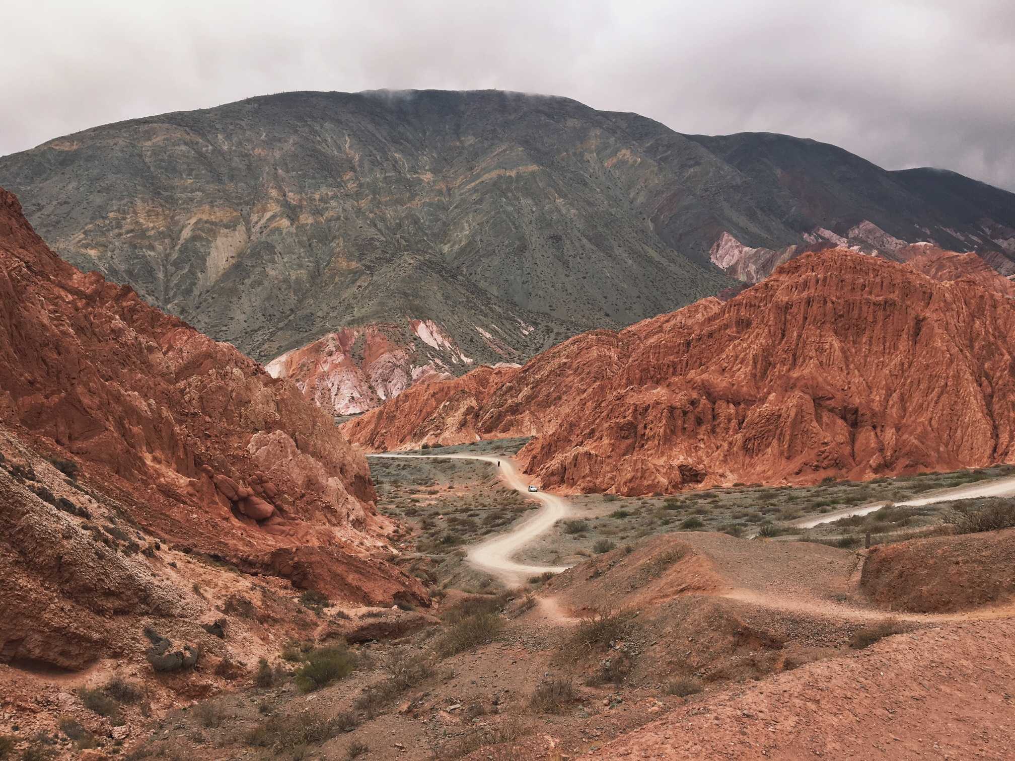
In the case of the Southern Alps, the rock was uplifted by the Alpine Fault. New Zealand lies right on top of an “inland” plate boundary between the Pacific and Australian plates. On the North Island, the oceanic Pacific plate is sliding deep under the Australian plate, melting and bubbling up magma, creating the volcanism and geothermal activity. On the South Island, the plate boundary is in the form of the Alpine Fault, a strike-slip boundary exactly like California’s San Andreas fault.
Along the Alpine fault, the Pacific Plate is moving southwest and the Australian plate is moving northeast. Over the last 15 million years, the two plates have slid 480 kilometers past each other, which is very fast by geologic standards. Increasingly, the two plates have started converging as well as slipping against each other, and as a result, pushed rock from deep in the ocean (schist and limestone in the Fiordland area) upwards to become the Southern Alps. They’ve risen 20 kilometers in the past 12 million years—again, a lot. If it weren’t for high rates of erosion, the Southern Alps would be a lot taller, but their highest point is Mt. Cook at 3,724 meters (named after Captain Cook, who named the Southern Alps).
We climbed and climbed, sweating, already beat, weary of the ominous day ahead. The view remained blocked by strange, mossy, twisting trees draped in lime-green lichen. The vegetation looked more and more like Dr. Suess the more dehydrated I got. Just as I was itching to call for a break we spotted a bright green kea in the trees above– the world’s only Alpine parrot, only found in New Zealand’s southern Alps.
A good luck sign! Lo and behold, a minute later we got the reward for our climb: we reached the tree line, or “bushline” as they call it in NZ. The view opened up suddenly, dramatically and in 360 degrees, with a glowing Alpine savannah unfurling in front of us like a shag rug of spun gold. Below as, Lake Te Anau shone brilliant blue, matching the shade of the distant mountain ranges and nearly cloudless sky: the Takitimu, Snowdown and Earl ranges. Better yet, a sign at the tree line announced that we were 45 minutes from Luxmore hut, where we could refill our water bottles. We had nearly the estimated hiking time in half. We stopped to stretch, hydrate and bask in the sun before taking our sweet time meandering along the meadowed ridgeline path, sun-drunk in bliss.
We took another glorious, sun soaked break at Luxmore hut, lying on the warm porch and doing a bit of yoga. Luxmore hut is my version of Luxury: at 1085 meters, it’s perched on a steep slope near the summit of Mt. Luxmore, with one of the best views I’ve seen in my life– overlooking dramatic peaks and a glistening fjord just below, like something you’d imagine in Norway. There were a gaggle of hikers eating lunch there when I arrived, and most of them were also headed for Iris Burns for the night. The hard work had paid off– we were caught up! And how did we luck out with this weather? Fiordland is known for its rain—we’d already experienced a typical downpouring day two weeks earier on the Routburn dayhike during Queenstown weekend, and were expecting something along those lines. Somehow, our bad luck was turning around a full 180 degrees. Dark night hiking, stumbling on gnarled roots and stupid mistakes had transformed into coasting on a gold and blue sunshine dream.
Leaving Luxmore Hut, I thought we had seen the best of the Kepler, but I was wrong. The ridglines, peaks and exhilarating vistas became more and more dramatic as we climbed on. We had passed the tree line, and were now nearing the high Alpine environment devoid of vegetation and dominated by scree as we approached Mt. Luxmore’s summit. The summit is the highest point on the track at 1472 meters. The earth fell away as we climbed a pile of moonscape-like boulders, wind whipping us violently, to peer down at the 360 degree panorama below. Mountain summits are so surreal; especially here, where we could see the lakes and patchwork farmland of the Te Anau valley just below while feeling as if we were on another planet.
Past the summit, the trail hugged impossibly steep mountainsides and followed a system of ridge lines with sweeping drops to the fjords below that gave me butterflies. We passed the Forest Burn and Hanging Valley emergency huts, which I’m sure are a godsend on a blizzardy day, but for us were just cute outpost cabins perched on the ridges.
We took a good, long break on the most spectacular ridge of all: Open and cliffed out on both sides, it was the skinniest, most spectacular ridgeline I’d ever seen. It wasn’t merely like traversing a backbone, but rather like tiny ants with backpacks tiptoeing along the green, spiky spine of a Spinosaurus— sleeping in the valley yet ready to rear up and buck us off like a horse swats flies with its tail.
Soon after the skinniest ridgeline, our descent began back into the densely wooded, glacier-carved valley. But just before we dropped below the tree line once again to say goodbye to mountain vistas, a kea paid us another visit. A kea had welcomed us up past the tree line, and here was another kea to send us off. As if it didn’t want us to leave, it blocked the trail with a stubborn stance and wouldn’t move even as I sat next to it and attempted to communicate in raspy purrs and whistles. What a strange bird. Our moment of spiritual connection turned into a nervous retreat on my part when I started to notice the size and chomping power of its beak so close to my hands.
Kea, aka “mountain clowns” are social, nomadic, and highly inquisitive. That combination of characteristics allows them to survive in a harsh alpine environment, by allowing them to find and use food sources. They’re also mischievous and endearing, which is especially useful when humans are involved. It’s thought that keas developed these special characteristics during the last ice age, when their powerful curiosity helped them find food in a desolately glaciated landscape. Today, they nest in boulders in high altitude forest, and are mostly vegetarian, but for a handful of insects when they’re feeling some protein. I think the kea is my spirit animal.
Once our descent began, we dropped fast. Now I understood why they told us not to come up this way. Within an hour, we descended 1,000 meters to under 500 meters of elevation at Iris Burns Hut and campsite, a quaint gathering of buildings in a hanging valley. After a 14 hour day (about 12 of them walking), we arrived just at dusk. The valley– a narrow strip of tussockland sandwiched between jungley pinnacles– was bustling with campers setting up tents and gathering cooking supplies.
The setting sun lit up an orange strip along the tips of peaks towering above, creating a rainbow of orange, purple and deep green. We proudly presented the warden our Iris Burns campsite tickets and rushed to get tents set up in the last lingering rays of sun as sandflies began their initial attacks. Sitting was bliss and our pasta dinner was bliss– even though we had to make about 15 rounds of noodles in our teeny pot. We sat at a picnic table as the air temperature dropped and sand flies continued to devour us. I overheard a German couple next door exclaiming about the day:
“Do you realize that we just did the best day of the best hike in New Zealand, on the best day of weather in the entire year?!”
I giggled thinking of last night’s screw up, but I think that some how, starting out on the wrong foot made our success even sweeter.
The next day’s walking was a flat, forested fairyland of ferns. We traipsed along valleys, up and down some easy wooded switchbacks, and through magnificent seas of ferns that stretched as far as the eye could see, like something out of Avatar. We almost stepped on bright red mushrooms– like the ones from Mario Kart– and peeked into hollows and nooks under tree roots that must house fairies.
Once we got to Lake Manapouri, we knew we were close to the end and the Moturao hut. We ate lunch on the beach and then walked to Rainbow Reach, where friends we had met along the way kindly gave Nick a ride to the Kepler car park to pick up our car and come back to get us, cutting 3 extra hours off our day. So we almost finished the Kepler: We did Rainbow Reach–> Moturao twice, skipped Rainbow Reach–> Kepler Car park, and all in all hiked 62 kilometers instead of 60. In one day we hiked what the guide book suggests you hike in 3. But screw the guidebook, we didn’t bring one. (ha….)
All the euphoria of having killed it at Kepler washed away upon learning about the Kepler Challenge, a running race that follows the entirety of the Kepler track’s 60 kilometers: the winners generally complete it in less than 5 hours. Compared to those hares, we’re an absolute herd of turtles, but a happy one.
The same content is published on my personal blog, A bird’s eye view.
This article has been archived, for more requests please contact us via the support system.
![]()


